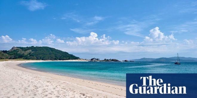
Islas Cíes, Galicia, Spain
Gaze west from one of the crows-nest hilltops on Monteagudo (“Sharp Mount”) island, and you can just about imagine the rooftops of Atlantis beneath the Atlantic swell. One of the three islands that comprise the Islas Cíes archipelago, about nine miles off the Galician coast, it is where Captain Nemo, hero of Jules Verne’s 1871 novel Twenty-Thousand Leagues Under the Sea, salvaged the treasure that funded his adventures.
Verne’s choice of location makes sense. Everything about this collection of islands carries a hint of myth and magic, from its coastal caves and high cliffs to its secret coves and squally seas. It was designated a nature reserve in 1980 and later a maritime park, and humans play a distant second fiddle to the permanent residents, which include such delights as the sea-pink “love plant” (herba de namorar) and an underwater algae forest a stone’s throw from the shore.
For all their Treasure Island-like wilderness (the other islands, south of Monteagudo, are Isla del Faro and uninhabited San Martiño), the big lure of the Islas Cíes is how close their crystalline waters and pale sandy beaches are to the mainland. In less than an hour by boat from Vigo (about €23pp), you can be sunbathing on Praia de Rodas, a Colgate-white strip of fine sand that links the two northern islands and can compete with any in the Caribbean. Children will enjoy snorkelling close to shore or rootling in rock pools in the main bay.
But the best thing about the Islas Cíes is that visitor numbers are capped, so there’s no scrum for space on the beach or long queues at the handful of eateries. Though the islands cover only about 1½ square miles, you can head off on any of four walking routes and soon be in splendid isolation. Except for the yellow-legged gulls that is: these squawking dive-bombers guard their nests with a gusto worthy of Verne’s swashbuckling hero.
The protective net thrown over the islands means accommodation and eating options are minimal. For a snack, grab some raya frita (fried stingray) or salmonetes (red mullet) at Bar Seafín. If you go for a day trip (as many do), enjoy an evening back in Vigo with a taste of classic Galician seafood at Casa Marco.
Stay The only place to stay is the campsite on Isla del Faro, which has pitches from €22 for two, or pre-erected family tents for €95 a night.
Oliver Balch
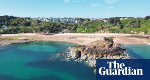
Île Sainte-Marguerite, near Cannes, France
A 15-minute boat-ride from Cannes, Sainte-Marguerite is a nature-filled island great for swimming, picnics and watching cormorants. A few years ago, we ditched the laser tag and paintball, and took our son and his friends there for his “alternative” 11th birthday. As we cut his cake in a glade among the umbrella pines and eucalyptus trees, none of the youngsters even glanced at their smartphone.
We usually head for the south side, with its rocky inlets, pebble beaches and clear water. At both ends of the island are the remains of a fours à boulets (cannonball oven). Built on the orders of a young Napoleon Bonaparte, they have a groove at the top in which the balls were placed ready to roll slowly down through the furnace until they came out cherry-red hot and ready for launching at enemy ships. This explanation provided the only moments of quiet at the birthday party, before the children scattered into the forest to hang upside down from twisted pines, play rounders beside the huge lagoon and stick-fight on the picnic tables.
On other trips, we’ve eaten at La Guérite (expensive, high-quality Greek-style seafood) and L’Escale (good for pizzas, salads and fried fish). There’s also a kiosk by the jetty called Le Leroños, selling pan bagnat, sandwiches and waffles.
Aside from the grounds of a few private homes, visitors are free to wander the trails that crisscross the island: there are no bikes or cars on Sainte-Marguerite. A pentagon-shaped fort, built in the 1620s, houses a slightly dusty maritime museum and a youth hostel (see below).
The narrow strait between Sainte-Marguerite and smaller Île Saint-Honorat can get so full of boats in the summer that you could almost walk across the decks from one island to the other. But 100 metres off this southern shore of Sainte-Marguerite is a protected zone, with an underwater eco-museum. It comprises six two-metre-high heads installed by British sculptor and diver Jason deCaires Taylor a few metres below the surface, that act as a refuge for marine life. Snorkellers can dive among the split-mask-like sculptures.
Stay The Centre International de Séjour is a hostel and activity centre within the Royal Fort, with family rooms and dorms in the former garrison. There’s a volleyball court, frisbee-golf and a climbing wall – better facilities than when the Man in the Iron Mask was incarcerated there for 11 years in the 17th century. Stays from €80 full-board for adults and over-nines, €68 half-board, plus one-off family membership fee of €26.
Jon Bryant
Ustica, north of Sicily, Italy
A short ferry ride from Palermo, the volcanic island of Ustica couldn’t feel further away from the messy, chaotic and colourful Sicilian capital. As soon as you dock in the main town’s pretty bay, it’s obvious how different island life is from the city.
Ustica is quiet, clean and sparsely populated. Most international visitors to Sicily don’t even know it exists. And because the island is only four square miles – a quarter of it protected nature reserve – it’s easy to get around on foot or by bike. It takes about half an hour to cycle from one side to the other, and you can circumnavigate the island in little over an hour. There’s also a bus if you don’t fancy the exercise.
The Greeks knew the island as Osteodes before the Romans renamed it Ustica – from the Latin for burnt, after its black rocks. History lovers will find much to investigate because it has been home at various times to Phoenician and Carthaginian settlers, Barbary pirates, and fascist-era political prisoners. But it’s the incredible natural beauty that draws most visitors, with divers flocking (or shoaling?) to its many inlets and grottos to enjoy some of the most pristine sea in the Mediterranean.
The waters around Ustica were made a protected marine reserve in the 1980s, the first of its kind in Italy. Experienced divers can explore shipwrecks, underwater caves and lava formations deep beneath the waves, but even casual swimmers will find lots to marvel at, and boat tours of the coast are deservedly popular.
Ustica also has a network of marked trails running inland, and the views from Monte Guardia dei Turchi, the highest accessible point on the island, can be breathtaking. Gorgeous tracks along the western and southern shores mean anyone with half-decent shoes and a bit of time can navigate the island’s coastline on foot.
Winding through farm terraces and clifftop scrub at walking pace allows you to properly appreciate the island’s beauty, and more often than not you’ll be the only one on the trail. To make the trek a little extra special, go after sunset, when you may find yourself under a tapestry of stars, with only the flickering of the mainland across the water to remind you that sooner or later, you’ll have to leave this paradise. Ignore them, and stroll back to the harbour for a glass of wine, or a meal at Il Faraglione, overlooking the water and run by two brothers who are passionate about modern Sicilian cooking and really fresh fish.
Stay Family-run Agriturismo Hibiscus, a 10-minute walk north of the main town and a stone’s throw from the shore, has doubles from €140 B&B.
Colin O’Brien
Tilos, Dodecanese Islands, Greece
The sea is rose and gold, waves surging to shore in the wild north of Tilos, where I sit in a taverna enjoying the sunset breeze. On the headland to the west, above Plaka beach, where peacocks roam, a wind turbine spins. This, along with a small solar farm, supplies all the island’s winter energy needs. Beyond, the road winds up precipitous cliffs to the monastery, with its flowing spring.
An island of 25 square miles in the southern Aegean, Tilos is peaceful, welcoming and down to earth. A hunting ban protects wildlife such as Eleonora’s falcons and Bonelli’s eagles, which swoop and circle overhead; monk seals find refuge on the rugged, undeveloped coast. Road hazards include cats, owls and goats.
When I came for a week in 2008 and walked through a valley of thyme and sage to a dazzling bay with watermelon-red sand, I was smitten. I discovered more footpaths to beaches with verdigris- and salmon-hued rocks, and stargazed from the abandoned hill village of Mikro Horio. Eventually I boosted the 500-strong population by one, moving to live here in 2011.
After a two- to three-hour ferry trip from Rhodes or Kos, you arrive in Livadia, which is encircled by green slopes and craggy peaks. Lining the pebbly beach are simple hotels, family-run tavernas (for a twist on traditional fare, try Almyriki or Gorgona), bars and Zafiris’ outdoor gym. Families with buggies, children on scooters and strolling couples enjoy the prom.
after newsletter promotion
The bus follows an oleander-fringed road through the empty middle of the island to Harkadio cave, whose museum displays the bones of the last elephants in Europe. Ahead, the small white houses of Megalo Horio appear below the castle. From the new archaeological museum, we ascend to the ancient village, where one cafe-bar spreads under trees, while another overlooks the arched roofs and pebble-mosaic courtyard of the church.
The bus turns south towards to Eristos, where I walk its kilometre of sand between wild rocky headlands. At the kantina, my beer can goes into recycling: Tilos went zero waste a few years ago. At dusk there’s a hushed calm, despite scores of tents under the tamarisks. Tilos has allowed wild camping on part of this beach for decades, and many campers return year after year. People sit watching the waves roll in; teenagers play traditional music on guitar and violin.
After the summer festivals, we walk the hills to chapels with frescoes, and wait for rain to bring wildflowers.
Stay Uno Apartments in Livadia has two-bedroom flats from €100 a night, and fancier Ilidi Rock has one-bedroom flats from €105 a night.
Jennifer Barclay
Rab, northern Croatia
Rab and revelry go hand in hand, especially in summer. The island in Croatia’s Kvarner Gulf is only 35 square miles, but it simply fizzes with joy and music and the scents of freshly grilled fish by the water’s edge. Having timed my visit to be there for Rabska Fjera (Croatia’s biggest and oldest medieval festival, held every July), I sat by the huge makeshift barbecue on Rab Town’s beach and devoured grilled mackerel (only €5 a portion).
There’s more feasting to come this summer, with Saturday fish festivals in August alternating between the villages of Kampor and Supetarska Draga. Then the Rab Jazz festival takes over (29 August-1 September), giving a spirited soundtrack to Rab Town’s Venetian splendour.
Climbing a staircase near pine-covered Komrčar Park, I enjoyed the best view of the town’s distinctive skyline: four medieval and Renaissance belfries above a sea of terracotta rooftops stretching along a narrow peninsula.
Down a nearby lane is the Ljetno Kino, the outdoor summer cinema that hosts the Rab film festival (23-27 August), as well as blockbusters and concerts, including the jazz festival. Nearby are the fifth-century ruins of the basilica of St John the Evangelist, whose 13th-century belltower is one of Rab’s fab four belfries.
Wandering through Rab Town’s labyrinth of marble alleyways, I found Konoba Rab, and gave the customary 24 hours’ notice for dinner the next night – succulent lamb cooked for hours under a cast-iron peka (a domed lid). It was worth the wait. Šanpjer restaurant along the harbour front has a no-reservations policy and lengthy queues for dinner; I settled for an €8 lunch of grilled sardines next day instead. The hands-down winner for setting is Restaurant Kamenjak in the foothills of Rab’s highest point – a great spot to watch the sunset.
Tiny Rab has nearly two dozen sandy beaches – a rarity along Croatia’s predominantly pebbly and rocky shores. Most, including two of the biggest, Rajska and Livačina, are on the Lopar peninsula. But some of us prefer pebbles, and that’s where the heavily indented Kalifront peninsula comes in, with sheltered coves at Gožinka, Dundo and Jelenovica, among many others. Even Rab Town’s mainly concrete beach, beneath the 11th-century monastery of St Andrew, became a favourite spot for a cocktail as the sun went down on this little slice of heaven.
Stay Arbiana Heritage Hotel has doubles from €110 B&B.
Mary Novakovich
Hallig Hooge, north-west Germany
I have many happy memories of European islands: Mont Saint-Michel glowing in the sunset; a quiet beach on Paros; Scillonian St Helen’s in a sea twinkling like diamonds. But the island that pops most readily to mind is in an unfashionable corner of the continent scoured by North Sea winds.
Hallig Hooge is the second-largest of the 10 Fenland-flat isles that make up the Halligen archipelago off north-west Germany. They are extremely low-lying, so whenever a storm tide breaches the protective dykes, they all but disappear beneath the waves. On Hooge, Landunter (literally “land under”) happens between two and six times a year. Yet, despite this, a mostly farming population of about 100 live what appear to be wholly contented lives.
In the main, that’s because their attractive barn-like houses sit safely on nine separate Warften, mounds that become islets when the sea bursts in. The floods are less frequent in summer, which makes this the best time for visitors to take the 75-minute ferry ride from the mainland.
Several summers ago, I disembarked with a few others at Hooge’s little jetty and soon found myself alone beneath a huge sunny sky. Looking out over seemingly endless saltmarshes flecked with purple and yellow wildflowers, breathing in silence and sea air, I felt my spirit lift. The feeling stayed with me for the four days I spent in this otherworldly place.
I picked up a hire bike and began swanning about the two-square-mile, virtually motor-vehicle-free island. I visited the tiny museum and church; watched a chilling film of a winter flooding at the Sturmflutkino (Storm Flood Cinema); and greeted horse-cart drivers with the customary cheery Moin! (pronounced mo-een). I bought food and Flensburger beer in Hooge’s supermarket and enjoyed languorous picnics in Strandkorben – canopied wicker benches – gazing at seals basking on sandbanks and seabirds drifting on thermals.
But it was impossible to ignore the sense of impermanence that clings to the isle. With sea levels rising, there’s a real danger that one day not too far off, Hooge and its merry Warft-living inhabitants may simply disappear or be forced to leave.
Stay Friendly guesthouse-cum-cafe Pension Hus Waterkant is close to the jetty and has doubles from €80 B&B.
Dixe Wills