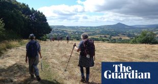
Start The Drover’s Rest, Monkhill
Distance 8 miles
Time 4 hours
Total ascent 70 metres
Difficulty: Moderate
Google map of the route
Allow Google content?
This article includes content provided by Google. We ask for your permission before anything is loaded, as they may be using cookies and other technologies. To view this content, click ‘Allow and continue’.
I first came across Burgh by Sands – a mile up the road from this walk’s starting point in Monkhill – in a 1970s magazine devoted to paranormal phenomena. In 1964, a Carlisle fireman named Jim Templeton took a photo of his daughter Elizabeth near Burgh (pronounced to rhyme with rough) only to find that, when he developed it, a strange figure in a spacesuit and helmet had mysteriously materialised behind her. The Solway Spaceman looked like a Doctor Who Cyberman and generated headlines around the globe, though most experts these days think it was just an over-exposed image of Jim’s wife, Annie.
That the marshlands of the English Solway should be the site of such a weird, Fortean event doesn’t seem all that surprising when you’re standing on one of the narrow wooden footbridges that span the deep tidal dykes, looking north across the wide, glimmering water. The Solway is a landscape of eerie, wind-blasted beauty. The light has a pale, ethereal brightness and the silence is so dense the ping of a phone alert echoes over the murky green flats like the toll of a church bell, sending flocks of sandpipers and golden plovers into panicked flight.
Inspired by the strangeness, local Anglo-Saxons decorated a wall of St Michael’s Church in Burgh by Sands with carvings of magical beasts. The Solway Spaceman is their Kodacolor equivalent.

Burgh is a postcard-pretty village around a green, its lanes lined with 17th- and 18th-century houses and a few of what are locally known as clay dabbins – cruck barns built from timber, clay, pebbles and hay. Walking north you pass a rush-thatched cottage with whitewashed walls and heavy buttresses that calls to mind the Vikings. It was warriors of another sort that made their mark here, though. Beside the Greyhound Inn stands a bronze statue of Edward I brandishing a sword and generally looking ready to take on all comers in the pub car park. The Hammer of the Scots died in Burgh in 1307. Sick with dysentery, the aged but still belligerent monarch was carried out to the edge of the Solway so he could call out the enemy with his dying breath.

A Victorian stone tower marks the spot where Edward Longshanks croaked out his final insult. It’s surrounded by iron railings to protect it from the chunky, shaggy-coated cattle that wander the salty land as if re-enacting the scenes JMW Turner captured in his etching, Solway Moss. Nearby are remnants of more recent conflicts – concrete observation posts and a target arrow (which, as if in homage to Edward Longshanks, points straight towards Scotland) – left over from the cold war, when this strip of the Solway was an RAF firing range.
Hadrian’s Wall begins to the west at Bowness-on-Solway, but there’s barely anything left of the stretch to Carlisle. Huge piles of the Roman masons’ precisely cut and crafted stone were carried off in the 15th and 16th centuries to build barns, houses and pele towers, thick-walled refuges for when reiver bands crossed the Solway on horseback via hazardous tidal fords or waths, to steal livestock and whatever chattels their victims possessed. There’s a good example of a pele at the eastern end of Saint Michael’s church.
The violence of the Anglo-Scottish border was given a romantic gloss by Sir Walter Scott. The great novelist loved the wildness of the Solway, and as you walk towards the mouth of the River Eden, you’ll see Old Sandfield, which features in Redgauntlet, his novel of Jacobite revolt, as the Lady Lowther Inn.

In the neat village of Beaumont, the Norman church is built on the site of a Roman turret. It’s barely 30 metres above sea level, but so low is the ground around it, the churchyard has commanding views that stretch from the north Pennines to the rugged brown hills of Annandale. Nearby is the course of a canal that once linked Carlisle with the hamlet of Fishers Cross, a dozen miles to the west (some of the bridges in Burgh were once aqueducts). In 1819, Fishers Cross was renamed Port Carlisle and investors promised that the new port would become “a second Liverpool”, bringing boom times to north Cumbria. The canal – deep and wide enough for 60-ton barges – had barely been completed when the railways arrived.
Port Carlisle’s backers swiftly filled in the waterway and laid a track on top of it. They were too late. A rival group had already finished the line from Carlisle to the dock at Silloth. Port Carlisle was abandoned. Now all that remains of this once-grand scheme is a terrace of houses, a chapel and a few crumbling remnants of the old wharfs, a monument to the effects of what we might now call disruptive technology.

The gleaming saltmarsh north and west of Beaumont is grooved with streams of dark water and the brackish muddy flats are filled with wading birds – godwits, redshanks, oystercatchers, turnstones and snowy white egrets – as well as half a dozen varieties of duck. The density of such succulent prey inevitably attracts raptors: peregrine falcons and hen harriers are spotted regularly and, if your eyes are keen enough, you may even catch a glimpse of the tiny, grey merlin whirling across the wide skies. In spring and autumn tens of thousands of barnacle and pink-footed geese and whooper swans land here on their way to and from their summer breeding grounds, the Solway’s enveloping quiet shattered by their mournful honking.
The walk south from Beaumont takes you to Monkhill, where a converted and bladeless 19th-century windmill looms protectively above the tiny hamlet like some cartoon creature from the imagination of Tove Jansson.
The pub

Drovers Rest is a traditional, low-slung pub with blazing fires and a warm, community feel. It has great beer, knowledgeable, enthusiastic staff and inventive, ale-friendly food. Co-owner and chef Tom McMaster is a former butcher who makes his own hot-smoked Cumberland sausages (vegan version available) to serve in homemade buns. The chips are chunky and crisp. Snacks include excellent pickled Czech cheese, and deep-fried macaroni cheese balls. There are about seven craft beers from northern breweries such as Ulverston, First and Last and Crazy Monkey, plus experimental brews from further afield. It’s the sort of place that makes you consider moving house to be near.
Stay
Hillside Farm B&B is on a working 1850s farm in the hamlet of Boustead Hill, four miles west of Monkhill. The location couldn’t be better. The farm is almost slap on Hadrian’s Wall, with open views across the Solway marshes to Scotland. There’s a double and a twin in the main house and a Georgian stable block has been converted into a bunkhouse with room for a dozen people. It doesn’t take card payments, so bring cash or a chequebook.
Doubles £90 B&B (single occupancy £60), bunk beds £15pp (fried breakfast from £4), hadrianswalkbnb.co.uk