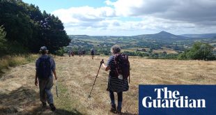
Ilkley Moor, West Yorkshire
Start/finish Cow and Calf Rocks car park, Ilkley
Distance/time 10.8 miles, 5½ hours
Refuel The Swan, Addingham
There is a tradition around new year to take to the moor. For me, it’s when this landscape is most intriguing: stripped back to its winter bones, all black rock, snowy heather and pinkish dusks, the lights of the Wharfe valley raked out along the river like embers. It calls to me as surely as the hillside ewes throating: moor, moor.
I know this place better than any, yet it always surprises with its geologies, wildlife and layers of lived history. Climb the track from the car park, pausing for views at the top of the Cow and Calf Rocks, and search among the Victorian graffiti for: “E M Lancaster 1st XXIV Foot, 1882”. Strange to think that three years before his mark was chiselled here, his regiment was fighting at Rorke’s Drift.
Follow the path up to Ilkley Crags, then head west along the high ground. You’ll startle grouse and, if lucky, see a merlin – the UK’s smallest bird of prey – hunting. Below is White Wells, a bath house from Ilkley’s spa town days where Darwin took the waters the day On the Origin of Species was released.
Drop down towards Hebers Ghyll Woods and look for the Swastika Stone curtained with iron railings. Depending on whom you believe, this is either one of the moor’s many cup-and-ring carvings, dating from the bronze age, or the chisel work of a homesick Roman soldier copying the Camunian rose patterns found in the hills of Italy.
The lower moorside track to Addingham is easy walking through farms and wintry fields. Though I’ve walked it a thousand times, I discovered only recently that the path briefly picks up the bump of the old Roman road that ran between forts at Ilkley and Elslack. Thaw out with a feast at The Swan. The best seat is by the old range, where there’ll be a fire, and pints of local beer (Saltaire Blonde, Timothy Taylor’s Landlord) will be well-earned. Return to Ilkley along the wooded banks of the River Wharfe as dusk falls. There’ll be the smell of wood smoke in the air and, as you rise through town to the moor and your starting point, tawny owls will be calling time on the last of the light.
Rob Cowen, author of Common Ground and The Heeding
Llyn y Fan Fach, Brecon Beacons

Start/finish Llanddeusant
Distance/time 4 miles, 2 hours
Refuel The Red Lion, Llangadog
There was every reason not to walk to Llyn y Fan Fach, a glacial lake cupped in the oblique flanks and eroded hilltops of the Black Mountain in Brecon Beacons national park. It was late in the season and already mid-afternoon. But the lake tugged me to it, and soon I was walking steadily uphill on a cold, crystalline day, wind pushing and shoving, winnowing into my ears and making them throb.
After about an hour the lake came into view, its surface blue-grey, the sandstone shore vividly red. And those emphatic hills, bookending the lake on two sides, gleamed a deep, velvet green. This primacy of colour in a place so devoid of incidentals seemed to speak more of the selectiveness of art than the randomness of nature. And art was what I’d come to visit. Llyn y Fan Fach is the site of one of the oldest stories inscribed in Wales’ dog-eared landscape: the tale of the lady of the lake.
You know the story: young farmer meets beautiful woman who emerges from beneath the waters. They marry, but there’s a catch: if he touches her three times with iron, she must return to her watery homeland. The couple enjoy a happy marriage, but iron is everywhere, and accidents happen. By the time he tosses her a bridle and its iron bit touches her hand, they’ve run out of luck, and she’s duty-bound to return to the lake.
Why iron, you may wonder. Perhaps the tale remembers the first encounter of technological difference in Britain. The lady belongs to the stone age people who left us the megaliths; the farmer is one of the technologically superior invaders, the iron age Celts. Iron, the story could be saying, is the way of the future, indestructible and deadly. Like the advancements that come along later – steel, bullets, nuclear warheads – it can make people disappear.
I shivered on the lakeshore, and not just from the cold and wind. Red kites circled overhead, drawn by the nearby feeding station. It was time to turn my back on ancient encounters and the lake itself, eel-black now with wriggling shadows, and dive down into the hills’ embrace. I fetched up at the Red Lion in nearby Llangadog, a Grade II-listed coaching inn whose historic warmth could thaw even the hearts of lake dwellers.
Pamela Petro, author of The Long Field
Warden Hill, Northumberland

Start/finish Just past the Boatside Inn and under railway bridge on road to Chollerford in a lay-by
Distance/time 2 hours/3¼ miles
Refuel The Boatside Inn, Warden
From high on Warden Hill I can look down on to two great river valleys. There, below me, the North and the South Tyne join, while away to the west is the tilted whinstone ridge of Hadrian’s Wall.
It’s no wonder that this commanding spot was chosen for an iron age hillfort. I stand at its centre, encircled by the three concentric rings and ditches of prehistoric earthworks. The name Warden comes from the Old English for a lookout hill, and the views from here are extensive and uplifting. It’s a winter walk to clear the mind and refresh the spirit.
I’ve been up here in the snow, on windy, buffeting days and on warm, blue-sky dawdling days with friends, on New Year’s Day, on birthdays … It’s that kind of place. This was the first walk I did in my first spring in Northumberland. A discovery then, but each time the seasons and the weather make it new. In late winter, hellebores flower by the narrow path, squeezed between railway line and steep woods, that leads to the intriguingly named Quality Cottages.
Then, it’s up through fields where worked flints have been found, skirting stone walls and hawthorn hedges, and across the flank of the hill to a wood of Scots pine that hugs the top. The wind quietens in the shelter of the regularly spaced trunks. Out into the light again and the summit views: Cold Fell in the west, the hills of Northumberland national park to the north, towns and villages, fields and woods, on top of the world.
Dropping down from the fort, the way winds through the hamlet of High Warden and on to a lane whose banks are bright in spring with wild garlic and red campion. The village of Warden hunkers down below the hill. To one side of the road the tree-covered Norman motte, to the other Saint Michael’s church, its Saxon tower partly built of reused Roman stone. To end at the 18th-century Boatside Inn adds yet another strand to this walk through layers of history.
Susie White, Guardian Country Diarist
Quiraing circuit, Isle of Skye

Start/finish Quiraing car park
Distance/time 4 miles/3 hours
Refuel Isle of Skye Brewery, Uig
Of all the creatures that have made their home in Scotland, perhaps the most fantastic are not the kelpies, mythical loch monster or unicorns, but the dinosaurs that once roamed what is now the Isle of Skye. The palaeocene-era Quiraing landslip is renowned for its distinctive geological theatre, but the Trotternish peninsula on which it lies contains as many mid-Jurassic -era stories. Here be no dragons, but the remains of dinosaurs waiting to be discovered.
To begin, park in the saddle below the much-photographed, 466-metre-high Bioda Buidhe, on the Trotternish Ridge, then walk north into a narrow gully at the brink of the landslip that eventually tumbles into the Minch. In the middle of this boulder-strewn gorge, the path scrambles beneath rocky overhangs into a labyrinth of thin columns and shadowy towers, all revealing different characteristics of the complex geology. Look out for the knuckle-shaped Prison, serrated Needle and, after a steep ascent, the grass-topped Table. Together, the skirmish of rock formations gives off a Mordor vibe, particularly when a murky haar underlines their dark personality. Skye’s name has several variations, but my favourite is Eilean a’ Cheo, “Island of Mist”.
While it’s tempting to see the pathway as a journey back in time, this is a well-trodden route, even if few make it past the first stile. Beyond here, take the left branch of the trail up and onto the Trotternish Ridge, there is a spectacular chance to savour the tussocky shoulder of Sròn Vourlin. It looks uncannily like the spine of a stegosaur.
From here, return by climbing the broad, sloped ridge, being wary of the sheer drop. Every pause – to take in the Torridon mountains across the sea, or to plan a fossil hunt on the nearby Rubha nam Brathairean foreshore – offers a moment for prehistoric discovery. Soon after, the path seesaws from a summit down across a boggy expanse of moorland and back to your starting point.
For more Jurassic encounters, and to put the Quiraing in context, pay a visit to Dugald Ross and his daughter Caroline’s Staffin Dinosaur Museum in Ellishadder. The Megalosaurus, Hadrosaurus and Ceolophysis fossils are terrific.
Mike MacEacheran, travel writer and guidebook author living in Edinburgh
Pyecombe circular, South Downs

Start/finish Pyecombe village, park on road by crossroads next to church
Distance/time 6 miles/3 hours
Refuel The Plough Inn
On the outskirts of Brighton, the ancient village of Pyecombe made the perfect starting point for a solitary stroll through Sussex downland, a gentle, unassuming landscape that nevertheless holds some secrets for curious walkers. I was searching for a memorial to Indian soldiers and a folly that inspired a ghost story.
With Pyecombe church gates on the right, I went over the crossroads, descended to – and crossed – the A273, followed a bridleway through a gate parallel with the road and, after 100 metres, veered left through a gate climbing to open land. In summer this chalk downland would be ringing with the sound of skylarks; today it is the throaty squawks of corvids.
I continued into a wooded area via a gate, crossed golf fairways and two fields to a treeline and wire fence. Through a gate I turned right, and after 100 metres the track turned left through another gate up the right side of a field. Waymarkers took me through another gate, and I descended a broad, chalky track with Brighton and the Channel in the distance.
Soon, a surprising sight came into view in this empty landscape – the smooth dome of the Chattri. An eerie, isolated and unique memorial, the Chattri was built a century ago for Sikh and Hindu soldiers who died while hospitalised in Brighton during the first world war. They were cremated here and their ashes scattered at sea. Granite slabs mark the site of the three original pyres. These soldiers had originally been hospitalised in Brighton Pavilion on the assumption they’d feel more at home with its “Indian”-style exterior. What they made of its kitsch, over-the-top interior is anyone’s guess.
I returned to the wide, chalky path and headed north for a 1½ miles, turning left on a path that became Mill Lane, passing the black and white Jack and Jill windmills. Reaching the main road, I turned left for 300 metres to a railway bridge. Peering over the wall I saw the startling entrance to the Clayton Tunnel – a 19th-century gothic folly-cum-castle. Why this almost Disneyesque feature was built over the tunnel remains a mystery. It was, however, the scene of a disastrous collision between two trains in 1861, inspiring Dickens to write his second-most famous Christmas ghost story – The Signal-Man.
Retracing my steps up the road, I turned left down a lane, then, after 200 metres veered left down a bridleway before rising through the woods in a long, gradual climb. At the top I traversed the crossroads and continued until the path becomes a drive, leading me back to Pyecombe and a well-earned pint at the Plough.
David Bramwell, musician, broadcaster and co-author of Cheeky Walks in Brighton and Sussex
Ansty to Bingham’s Melcombe, Dorset

Start/finish Ansty
Distance/time 3 miles/1 to 1½ hours
Refuel The Fox Inn, Ansty
In winter, when arable fields are bare, sparkling with flint and stalked only by pheasants, the middle of Dorset seems empty. But buried in its landforms, this well-signposted walk has both history and variety. The footpath led me from Ansty under massive oaks by Marsh Water, taking me west across a cattle-churned field which made me grateful for my walking boots, and through bare beech woodland to a wide avenue of trees leading to the grand, isolated house at Bingham’s Melcombe. Neither house nor garden is open to the public, but I marvelled at the huge evergreen hedge that overhung the bowling green on the other side of the precariously leaning wall, a scene reminiscent of David Inshaw’s painting The Badminton Game.
Coming round to the front of the house, I found the small, square-towered church of Saint Andrew’s. The shady burial area in the churchyard set aside for beloved pets (one headstone reads “Hugo 1948-1960, and in memory of his friend Treasure”) might lead you to believe this was a private chapel for the big house; actually, it’s the orphan of an earlier settlement. Clambering on to the churchyard’s compost heap, I peeked over the hedge. Beneath the lumpy field beyond, lit with low winter sun, lies the medieval village of Bingham’s Melcombe, abandoned some time before the end of the 15th century.
Leaving the lost village behind and crossing a small bridge by the fishpond, I climbed a track that led into a holloway, where hart’s-tongue ferns licked at the chalky path. My day was dry, but in wet weather this would soon run with slippery rivulets. Briefly taking the high road, where long views unfolded across the valley to the south, I came down to the watery village of Aller, which has brooks and ponds everywhere, before returning to Ansty. The energetic and curious can extend their walk another mile or two through modern Melcombe Bingham to another abandoned village – Melcombe Horsey, lonely in an open valley with only farm buildings and a house for company, not far from the Dorsetshire Gap, where five ancient trackways meet.
Jon Woolcott of the Little Toller independent publisher and bookshop; he is currently writing Real Dorset
Bradwell-on-Sea, Essex

Start/finish King’s Head pub, Bradwell-on-Sea
Distance/time 6½ miles/3 hours
Refuel King’s Head
The remote, seventh-century chapel of St Peter-on-the-Wall stands on the Essex coast near the wide, wild Blackwater estuary. It is one of England’s oldest churches and still regularly used for services. A hike there along the sea wall above saltmarshes and shell-carpeted beaches has a bracing, cobweb-clearing feel, especially in blustery January, when the tidal mudflats are busy with overwintering waders: several kinds of lapwings, curve-billed curlews, redshanks and black-and-white oystercatchers.
In 653, St Cedd, a Northumbrian monk and bishop, sailed down England’s east coast from Lindisfarne and landed near a ruined Roman fort called Othona. The following year, he used stone from the abandoned fort to build the chapel. St Peter’s is towards the end of this coastal loop from Bradwell-on-Sea.
The walk starts near the newer St Thomas’s church, heads over the fields to Bradwell Waterside, with its 350-berth marina, and past the looming towers of a decommissioned power station. There are views across the water to beach-hut-ringed Mersea. As you round the tip of the peninsula heading south, the scenery gets steadily wilder.
The wide, waterlogged area on the left is the largest continuous saltmarsh in Essex. Winter brings thousands of birds to roost and gather in murmurations: godwits, divers and dark-bellied Brent geese. When the tide is low, look out for submerged Thames barges. Some wooden posts far out on the sandflats are the remains of a Saxon fish trap that probably supplied the monastery. Centuries of tides have left this coast with a long bank of cockle and oyster shells, where silvery sea holly and samphire flourish; yellow horned-poppies and purple sea lavender flower in summer.
Eventually, hidden in trees on the right beyond the Othona Community, you reach the simple stone-walled chapel, which has long been visible on the horizon. The doors are almost always open and, inside, rows of benches face a cross on the east wall. A 45-mile waymarked walk called St Peter’s Way arrives here from the other direction, meandering up the marshy coast after its pilgrimage across Essex from Chipping Ongar. The stony track that leads away from the sea becomes a lane through houses. Follow it past the Cricketers pub and St Cedd’s school, back to Bradwell and the welcoming King’s Head along the course of an old Roman Road.
Phoebe Taplin, author of Scenic Walks in Hertfordshire and Essex
County Down coast

Start/finish Ballyhornan Bay/Ardglass
Distance/time 5 miles/3 hours
Refuel Ardglass Golf Club restaurant
Mist swirled in a dazzle of moisture as the sound of incoming waves crashed against the shingle beach on which I trod. The sky had turned a thick shade of pewter and, for a good few minutes, I was walking in a state of partial sensory deprivation.
Then, almost as suddenly, it dissipated and I could see all along Ballyhornan Bay, the rise and fall of its dramatic rocky clifftops stretching into the retreating clouds.
It was a fittingly biblical introduction to Northern Ireland’s County Down coast (which pokes out into the Irish Sea, between the major centres of Belfast to the north and Newcastle to the south), because I was on an ecclesiastical mission myself – or at least I had been. Fresh from walking the St Patrick’s Way – a fairly “new” pilgrim path (circa 2015) that runs between Armagh and Downpatrick – I had a hankering to stretch out my legs on something shorter.
I found this coastal stroll almost by mistake when visiting the Downpatrick Centre to collect my certificate, AKA Irish Compostela, and discovered that two nuns had researched another pilgrimage that followed part of this coastline.
It starts at Ballyhornan, said to be the area where Patrick arrived in the country by boat with the sole aim of bringing Christianity to Ireland, and heads south to the town of Ardglass, mainly on a signless rough track following the route of the much longer 47-mile Lecale Way.
I strolled the rocky beach, watching gannets dive into the water near the green mound of Guns Island just offshore. The faint trail soon plunged into grassland festooned with wild flowers, then climbed to high clifftop, where the roar of the ocean reverberated as it bounced against the rock. In the distance I could make out the shape of the Mourne Mountains.
Finally, a walled enclosure appeared alongside. Inside was a fabled natural water source – a small, circular holy well in the ground, overlooked by a freshly painted crucifix, once said to be the place where the patron saint christened the first Irish people, and which could cure any ailment. From its edge I could look inland, where the final section of this walk would see me wander past the remains of the 15th century Ardtole church, one of the oldest in the country, which Patrick also founded.
On the spot I stood, I later found I later found sepia photographs online showing huge crowds gathered back in 1911 on a pilgrimage to the healing waters, standing where I had stood. And while I didn’t plunge into the sacred water source, through this walk an immersion had still taken place, one that saw me, like the gannets, dive into the wilds of the east coast and emerge with my eyes wide open. I can only thank Saint Patrick for that.
Saint Patrick’s Centre runs guided walks on this route from May to September. Ulsterbus 16a runs twice daily back to the start, for one-way trips.
Phoebe Smith, author and host of the Wander Woman podcast
Watlington Hill, Chilterns

Start/finish National Trust car park, Watlington Hill
Distance/time 7 miles/4 hours
Refuel Fox and Hounds, Christmas Common
There’s something particularly magical about ancient routes in winter. Curls of wood smoke, the chatter of a startled blackbird, dew-draped webs – in this weather, I feel like I’m walking in the past. Everywhere you look on this walk are signs of earlier generations who built their lives in this land. Watlington Hill may look untamed but it’s the result of centuries of sheep farming that transformed it from woodland into rare chalk grassland, now home to numerous endangered insects and plants.
Commanding views across the Thames Valley reveal a patchwork field system – a result of 18th- and 19th-century land enclosures, whereby larger fields were divided up and hedged, and common land was privatised. The result? The poorest country dwellers, reliant on the common’s free resources, were forced into towns to look for work. Hedgerows themselves are now in need of protection – they’re important wildlife corridors in intensively farmed landscapes, and a key tool in our race to decarbonise.
Head downhill along the edge of the White Mark – a chalk triangle cut in 1674 to give the illusion of a spire on the parish church when seen from a distance. At the bottom of the hill, turn left on to the ancient Icknield Way. Running from Norfolk to the Dorset coast, this route is one of the oldest in the country – many archaeologists believe its origins are prehistoric. After a mile, turn left to head south towards Dame Alice Farm – look for the unusual chalk stone cottage, then meander along the trackways to Dumble Dore (perhaps an inspiration for JK Rowling?) and on to Greenfield Copse. Here you’ll spot 2,000-year-old iron age earthworks – probably the remains of a homestead or livestock enclosure. There’s even history in the trees – look for coppiced beech trees, which have been cut down and allowed to regrow more than one trunk from the same base (known as a “stool”). It enabled people to get more usable timber from one tree, and it’s an indicator that a woodland is very old.
From here, loop round via Hollandridge Farm and along the unsurfaced Hollandridge Lane. It’s a Saxon route – more than 1,000 years old – which acted as the spine road for the 12-mile-long “strip parish” of Pyrton. The “strip” takes in land on the valley floor (best suited for settlements, offering shelter and reliable water sources), but also rougher land on the hillside and tops of the chalk escarpment, which was valuable for seasonal grazing, woodland and quarrying.
The footsteps of ancestors will then lead you to the Fox and Hounds at Christmas Common. Mead optional.
Mary-Ann Ochota, TV presenter and author of Hidden Histories: a Spotter’s Guide to the British Landscape
Thompson Common, Norfolk

Start/finish Thompson Common car park
Distance/time 8 miles/3 hours
Refuel The Chequers Inn, Thompson
The first time I went to Thompson Common, I managed to miss its unique, historic, stupendous feature. It is that kind of place – a tranquil and unassuming landscape of woods, bushes and little grassy glades. In summer these meadows are filled with orchids and dragonflies. In autumn, there are fungi and spiders’ webs, and in winter there’s a hush to the place and a glimpse of a roe deer on the far side of the clearing.
But the discovery here is easier to spot on the Ordnance Survey 1:25,000 map than in the place itself: this calm, green landscape is pitted with mysterious little ponds.
Thompson Common is the “pingo” capital of Britain. A pingo is an ice age pond, derived from an Inuit word for hill. These ponds were formerly hillocks of ice beneath frozen tundra. When the ice age drew to a close, they melted into little round ponds. There are at least 400 on the common, but most are hidden beneath centuries of reeds and other marsh plants, or shaded by birch and ash. Each is a miniature world and time capsule, packed with rare plants and animals.
There are 57 rare species living in this pondscape, from the scarce emerald damselfly to the northern pool frog, Britain’s rarest frog. There is also the minuscule pond mud snail. None is likely to be visible in winter – you’ll see the damselfly on the wing in midsummer, when the air is alive with the croaking of frogs – but the landscape feels richer if you know they are there.
This walk can just be a potter around Thompson Common, which is protected by Norfolk Wildlife Trust (so no dogs), or a hike on the Great Eastern Pingo Trail, following the old railway line south-west into some classic Breckland heath and woods. Then it’s a turn to the north-west, up the arrow-straight Peddars Way, an old Roman road that follows the chalk into west Norfolk. After a mile, turn east again around the north side of Thompson water (a humanmade lake) and back to where you began.
There are more pingos to find, and more now being resurrected in two new nature reserves. Norfolk Wildlife Trust is excavating “ghost” pingos ploughed up or filled in by farmers a century ago. The uniqueness of this overlooked landscape is, belatedly, being recognised and revived.
Patrick Barkham, Guardian natural history writer