Is this bag too heavy? Do my boots pinch? Am I fit enough? Do I look a complete anorak in this cagoule? There is nothing like the prospect of a multi-day, long-distance footpath to rouse lurking anxieties and keep you awake at night for weeks beforehand. And there is always the helpful soul who insists you must take a particular item: a thick hardback volume on the benefits of walking? Lovely.
A selection of artisanal cheeses and a bottle of fizz? I’ll squeeze them in somehow. Once for me, in Yemen, it was a pistol, presented with the comforting words: “Take this – you’re going to need it.”
Then, finally, you begin. You are moving and eventually comes the realisation that, assuming you manage the feat of placing one foot in front of the other, you will make it. You dump the hardback book and pistol, scoff the food, quaff the drink; your bag gets significantly lighter. The sun comes out and all the mountains stand before you. With luck, there are no more cars, no power lines or pavements for a long time to come.
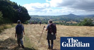
Within a few hours you are looking back and saying, “I can’t believe I’ve walked so far already!” Within a few days, you say, “I just want to keep going forever.” (There will be moments when you bitterly regret that one.) You have entered the real world, the one you now prefer. You are a long-distance European mountain walker. So here are some ideas, some real walks to be considered.
The Malerweg (Painters’ Path), Germany

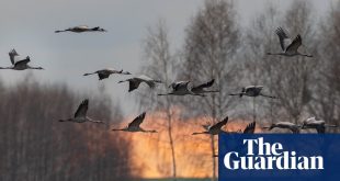
In 1766 two Dresden art teachers, Anton Graff and Adrian Zingg, set off on a trip into Saxony, heading through the town of Pirna, south-east of their home, into a region of mountains, mists and deep valleys that now straddles the border of Germany and the Czech Republic. Other painters, including Caspar David Friedrich, soon followed, triggering a romantic art movement and a love of hiking.
In 2006 a new path, the Malerweg or Painters’ Path, opened, a 71-mile circuit that has quickly become a German classic. Normally done over eight days, the walk takes in highlights such as sandstone outcrops and massifs such as the Schrammtor and Schrammsteine, where the trail burrows up narrow canyons, often on ladders, to magnificent views. Don’t bring a massive, wide backpack – you will get stuck – but come with sketching gear. There is plenty of accommodation in guesthouses along the path, but there are some campsites, too, and pitching under rock overhangs is tolerated.
More details on the official website: Malerweg. Hiking Navigator has a very useful stage-by-stage guide
Tours The Natural Adventure Company offers a great self-guided walk of the Malerweg from £765pp, which includes nine nights in hotels, luggage transfers and breakfasts
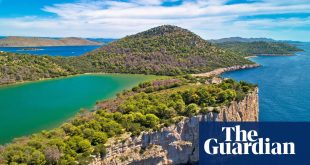
Alta Via 1, the Dolomites, Italy

It was on the Alta Via 1 that I first experienced the magic of the Dolomites. We had hiked up the trail to the Rifugio Nuvolau mountain hut in broad sunshine, but as the day ended clouds came rolling in from the Adriatic Sea, blossoming above the 3,000-metre peaks in dramatic thunderheads that were then slowly torn apart by the wind in the dying rays of a ripening red sun. In many years of mountain walking and climbing I had never witnessed anything like it. Eventually we went inside the hut for a hearty, home-cooked dinner and asked the manager if he’d seen the spectacle outside: he nodded, grinning, “Yes, every night.”
The Dolomites, named after an 18th-century French mineralogist, are an Italian extension of the Alps that regularly pull in the Adriatic clouds to adorn their stunning peaks and rock formations. Cinque Torri, the Five Towers, is just one clutch of crags that lies on the Alta Via 1, a north-south hiking route that also passes valleys (decked with flowers in season), waterfalls, epic ridges and some fascinating first world war history. Most walkers start in the north at Lago di Braies (spend a night there if possible – it’s beautiful) and take 10 days to reach the finish at La Pissa, 74 miles away, but there is no reason you couldn’t do it the other way around. It can be done faster, but the terrain is tough – don’t underestimate it. Some via ferrata (steel climbing fixtures) can be included, which are great fun, but you’ll need a harness and a lanyard.
There is no wild camping allowed, but the accommodation is a prime attraction on this route: the stop before Nuvolau (only accessible on foot) is Rifugio Lagazuoi, a larger but equally enjoyable place that sits on an escarpment above a complex network of first world war tunnels. The hut can sleep about 70 and is accessible by a cable car, so it is a lot busier than others, but the atmosphere and panoramas are as good as anywhere. Allow a day to explore the tunnels and trenches. Outside this short honeypot section, you will encounter only a few other hikers and climbers.
More details Visit Dolomites; maps: use the Tabacco editions; books: Trekking in the Dolomites by Gillian Price; The Dolomites: Rock Climbs and Via Ferrata by James Rushforth
Accommodation Booking at the rifugio is essential
Tours Collett’s Mountain Holidays specialises in the area. Alpine Exploratory does self-guided and guided versions of the complete 74-mile ute
Mount Triglav, Slovenia

At a mere 2,863 metres, Triglav might seem like an Alpine pimple, but be warned: this is a serious lump of rock, requiring careful preparation, and also home to several of Europe’s most incredible walks. All routes require at least two days for normal mortals; more if you actually want to enjoy the experience. The most demanding ascent is called the Bamberg, and requires nerves of steel on the iron cables. Head for the top of the Vrata Valley and a night in the Aljažev Dom hut. Ahead stands Triglav’s legendary North Face, a near-vertical kilometre of karstic limestone.
The Prag route to Krederica hut is easier than the Bamberg, but still requires steady hands up some vertical sections – all well protected as long as you use the via ferrata correctly. Triglav is a very dry place (except during summer thunderstorms), so bring lots of water. The Bamberg itself takes you through a series of tough vertical pitches, narrow canyons and plenty of exposure, as climbers call it, popping out on a rocky plateau that takes you to Planika Hut for a possible overnight before the final ascent.
If you really don’t like the prospect of a via ferrata – and they’re not everyone’s bag of wire – try the Krma route, which starts from Kovinarska Koča hut, rising up to the Krederica hut at 2,515 metres. The final ridge does involve some via ferrata cables, but the summit is in sight and is worth it.
More details Triglav national park
Trips (tours) Much Better Adventures runs various two-night trips to Triglav from £392, including guides, via ferrata equipment, meals, accommodation and airport transfers
Turnov to Jičín, Bohemian Paradise, Czech Republic

The Czech Republic has some fine walking routes, but none beats the exquisite labyrinth of sandstone rock towers in the east known as Bohemian Paradise. From the start in the town of Turnov, this feels like moving into a Mitteleuropa of a slower, more ancient vintage: villages that cluster around castles are dotted across a landscape of mountains, meadows and forests. The path heads south and soon begins to bump into isolated rock towers and natural grottoes that become more and more grandiose and dramatic. If they were the fanciful rock follies of some deranged Austro-Hungarian princeling, it would be no surprise, but they are completely natural.
At Prachovské Skály the geological eccentricity reaches its apogee: this is a baffling playground of towers, canyons and stairways (humans have played a minor role here) that is difficult to leave – partly because it is so delightful and partly because it’s hard to find the way out. No wonder film location scouts looking for a gothic or medieval fantasy hideout often end up here. Walking north to south is preferable, because you finish in Jičín, an imposing old city with a beautiful square and market. However, going in the other direction does open up the possibility of connecting with the E3 long-distance path.
More details Visit Czech Republic
Tours On Foot Holidays does a six-night trip from £635pp including breakfasts and luggage transfers
France and Spain: GR10 and GR11, the Pyrenees

Having warmed up on short hikes like the other five mentioned here, you may be ready to really stride out. For this I suggest the GR10, which traverses the entire length of the Pyrenees, a distance of around 900km. At the end of your 50- to 60-day walk, you will have climbed the equivalent of more than five Everests (about 48,000 metres of ascent). I have done a few sections and it is superb high-country hiking. There are in fact two paths: on the French side of the border is the GR10, the Sentier des Pyrénées, and on the Spanish, GR11, the Senda Pirenaica.
Overall, the French side is a slightly easier option: there are more mountain huts and more walkers, while its altitude is slightly lower. Both paths are spectacular, with stunning scenery including the Añisclo Canyon and the Cirque du Gavarnie.
For those without time for the entire hike, these two highlights can be done as day walks. The wildlife is special: chamois, marmots and bears (although you are very unlikely to see one), plus wonderful birdlife, especially during migration periods. As both paths rise above 2,500 metres, they may not open until late June, or even into July, whereupon thunderstorms become a danger.
More details Walking the Pyrenees , with a blogfrom Steve Cracknell, who walked both routes; Cicerone guide

The Glockner Circuit, Austria
Occasionally you go somewhere, you walk, you see no wildlife, the clouds come down and any views go no further than you could chuck a walking pole. So it was when I first hiked in Austria’s vast Hohe Tauern national park. We were unlucky with the weather, and the wildlife. But everything else was magnificent: the forest, the waterfalls and the cosy mountain huts. The Glockner Circuit is an Alpine classic: 71 miles of tough footpath that circumambulates Austria’s highest peak, the Grossglockner (3,798 metres).
Start with a 660 postbus from Zell am See (which has international rail connections) to Kaprun, then make for the trailhead, where you start on an anticlockwise route around the peak. With luck you’ll see bearded vultures, golden eagles, steinbock and ibex – and even without it you will enjoy Austrian dishes like Kaiserschmarrn (a sweet pancake served with plum or apple sauce) and Käsespätzle (a type of cheesy pasta) in mountain huts such as Rudolfshütte (there’s a big climbing wall inside) and Salmhütte (recommended). This is a summer walk, but even then some of the higher sections can be impassable, with hikers forced to take lower alternative routes. It’s definitely not one for beginners.
More details Hohe Tauern national, and also Carinthia Tourism, where there is a useful brochure to download
Accommodation It’s worth joining the Austrian Alpine Club UK for access to huts

Walk this way…
Advice from the experts
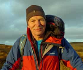
Mick Fowler
Mountaineer and hill walker who specialises in bagging unclimbed peaks, the type that invariably require long-approach hikes
I always take a bivvy bag with me, Polartec gloves and a spare pair of socks – there’s nothing like clean dry socks in the morning! For mud and snow, gaiters are essential, and I find that trekking poles – love them or loathe them – protect my joints. To stay warm, layering is essential: base layer, fleece, then a down jacket. For me, the development of waterproof down jackets with a hood, like Berghaus’s Tephra, has been a game-changer. As far as your bag is concerned, get something big enough and don’t overstuff it; they get out of shape and uncomfortable. I generally take a 65-litre sack. Use compression straps to reduce size.
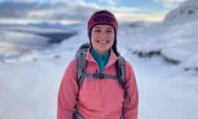
Kirsty Pallas
Mountain leader and instructor based in Oban, Scotland, where she is also a member of the mountain rescue team
I would say never use new equipment on a multi-day hike. You want to know that it all fits properly. There’s nothing worse than a rucksack that gets uncomfortable on day two. I always take spare laces and duct tape wrapped around my walking poles – that way I know I can always fix a boot, a tear in a tent, even a blister. I use a water filtration bottle to avoid disposable bottles. For warmth I particularly like the Patagonia R1 range: recycled materials and cosy on winter climbs.